4/23/21 Up and about at our campsite at Cave Lake, a brisk morning but sunny as can be. The temp dropped to 22deg last night, but we had our heater on, so thankfully no pipes froze.
Driving to Great Basin National Park, beautiful scenery in these basins leading up to it. When we get to the visitors center, I learn that the Great Basin park is really representing the entire state of Nevada, the Great Basin being the entire basin and range topography that covers the area from the eastern Sierra all the way to the Wasatch range.. Unfortunatly the Wheeler Ridge Scenic Drive was still closed on account of snow, and the Lehman Cavern is closed for season and covid, so we weren’t able to get the full experience of the park on this visit. But it is still a beautiful place to camp.
We are in the Lower Lehman camp, and we beat the weekend rush, got a really nice space. For the afternoon, we took a short nap; the luxury of all time! Some time to mend buttons, write in my journal, and things like that. We just figured out that we can locate Phil’s phone by yelling “Hey Siri”, and it beeps. Woohoo!
4/24/21 Leisurely breakfast of leftover veggie stir fry with eggs and tortillas, and it warmed up enough to sit out at our picnic table and pleasantly linger through a whole cup of coffee. Then, on with the day. We stop at the Baker Archeological site and look at the since-covered-up foundation sites of a Folsom native american population from 1200ad. Then onward over hill and dale, off to Utah. Continuing our drive, through breathtaking basin and range topography, Utah started out extremely barren and brown, but over each range we crossed, there was more green, and more signs of current human activity.
The mountains between the basins were absolutely spectacular, each one getting more dramatic as we headed eastward. The Wasatch range left no understatements; it was just as majestic as it could possibly be. With the Utah agricultural landscape rolled out at the floors of the valleys, and the mountains standing as silent back-drop to this quaint picture, it was beautiful.
We texted Daniel that we were heading up toward Provo, and he told us to check out an abandoned solar R&D site, and the Topaz internment camp, both on the way.
Walking around the site, you can feel that dark moment in modern history, and hope that the monument serves to remind us that hate and fear can not dictate laws against our own innocent citizens.
Then, we rolled into Provo and met up with Daniel and Tiffany and their two boys, Henry and Harrison. What a lovely young family, we had such a great visit! Daniel has built water systems for hydroponics, builds any parts he needs with his 3-d printer, does absolutely everything, wiring, rebuilding RV’s, and now he wants to become a pilot. It was a real treat visiting, and Tiffany and their boys are delightful.John and Nancy also returned from a diving trip last night, so we all got together for lunch at Daniel's and Tiffany's today.
We had a very nice visit! Thanks Daniel and Tiffany for having us! Off we go now, to stay at a KOA to recharge, refill and plan for the next few days.
4/26/21 RAIN! it is welcomed here, as everything is so dry. The sw counties of Utah have moved their fire danger season a month forward, as I'm sure California has as well. But, here comes the rain, like manna from heaven. We aren't too crazy about hitting possible snow in the mountains though. We're putting a Plan B together, just in case. We've checked into the Sam Stowe campground in the Fremont Indian State Park, near Sevier, Utah. There are surreal outcrops of rock formations every direction you look, and petroglyph sites throughout the park! It is raining, so we check out the little museum at the visitors center and do some homework and map studying for hiking tours we will take tomorrow to see all the petroglyph. It's a nice, rainy day (finally) and we are cozy and happy, hanging out in our fancy tin-can on wheels (oooh, sorry Lexy!) and catching up on being right here, right now.
We have leisure time, and electricity hookup, so I venture to make a Shepherd's Pie. Yum!!! 4/27/21 We wake up, and there is a thin blanket of snow everywhere! Since we got a camp spot with electricity, we have this trusty little electric heater that we run, mostly to keep our water lines from freezing, and I'll admit, keeping us comfortably warm without using up our propane running the heater all night. Although we still have intermittant flurries mixed with frozen rain, we had some cool petroglyphs to check out! So, we bundled up and went on a number of short hikes that had interpretive signs along the way, scattered throughout the park.
There were so many rock facings that looked like perfect large canvasses for anyone that took residence in the valley here; I can see how nearly every rock face had some drawing on it.
Petroglyphs and pictograms were just absolutely everywhere! I stopped taking pictures, just feeling so overwhelmed with so many places to aim my camera. The rain and snow finally subsided around 2pm, so we picked up our paces a little, and got one more "chapter" of local anthropological history in by viewing the pictures on the rocks in one last section of the canyon. This one has 31 sets of hand prints.
We liked this park so much, we decided to spend the whole day roaming in the canyon, and are staying for another night, here in the lap of luxury with electricity and water hooked up to Lexy, and beauty surrounding us.

4/28/21 Up and At 'em! Today was a spectacular day for sightseeing geologic landscapes. We drove from Folsom Indian State Park down to Quail Creek State Park, near Zion national park in Utah. This terrain is absolutely gorgeous! We started on a frontage road along hwy 70, to Sevier, UT.
Then, we headed south. Beautiful valleys and meadows surrounded by mountains. We followed state route 89 south, paralleling the interstate 15, and then cut across to 15 along state route 14.
highway 89 near Junction, Utah Family Reunion Courthouse in Junction, Utah The house that Butch Cassidy grew up in. The dirt road we followed for 7 miles To see Strawberry Point, but it got too muddy for us!
view of Zion and all of southwest Utah, from 9900ft.
I really wanted to see Cedar Breaks, but the road is still closed on account of snow. Maybe next time! This highway 14 is just one of the most scenice roads I have ever been on. Not recommended for semi's, but our 21ft nimble Lexy had no trouble with the mountainous terrain. Just past the closed road to Cedar Breaks was at 9900 ft; I had no idea we were so high up! No wonder the road was closed.
Onward to Kolob Canyon, just south of Cedar Breaks. We only realized that this was within the Zion national park boundary once we got there. Phil has his forever-pass, so we got in free! We drove to the end of the road, and then hiked a mile into the hills to get the most spectacular views of this incredible canyon.
Heading to our destination for this evening, Quail Creek State Park (Utah), just outside the main entrance to Zion National Park. We figured this was just a night to bide time, to be close to the entrance to Zion so we could get a good day of sight-seeing in before I have to start teaching (and take my own voice lesson) at 4 (mountain time) tomorrow. We pulled into Quail Creek, and saw the most beautiful reservoir, and then found our campsite that I had reserved a few nights ago.
Wow!!! Set uphill from the shoreline and the rest of the campsites, we have a full view of the lake. The air is nearly balmy, not too dry but not damp, not cold but not hot either. Everything about this place is just perfect.
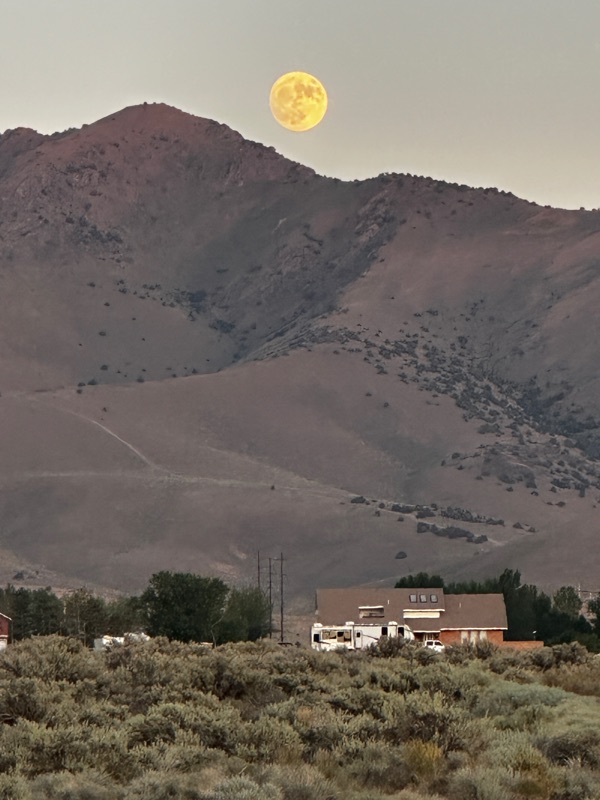
We are sitting at our picnic table, under an aluminum awning that is breaking the gale-force wind on us, and waiting for the moon to rise. We missed the super moon last night on account of clouds. Tonight there isn't a cloud in the sky, and our eastward view is unobstructed over the lake, framed by beautiful mesa tabletops. Where is that moon??
4/29/21 Ahh, but we hate to leave this beautiful spot! But, zion National Park awaits! We fuel up on gas and propane at the Chevron in Hurricane, and take a short detour into the Walmart there. Picking up a few staples, and of course some Buffalo wings for Phil from the deli, we're on our way to Zion. We head up hwy 9, but then take a detour up Kobol Terrace Road, changing course at Virgin. We thought we'd get the view from the outside, looking in, and head up, up, up to the terrace top.
we stop just 3 miles shy of the reservoir at the end of the road, when the sign said no vehicles over 19ft permitted. Darn, we measure in at 20ft 11in..
On the descent, we saw a perfect place to pull over, and get our lawn chairs out. Ahh, the air is crisp and clean, and a swift breeze reminds us that we're at 6000 ft.. We start out in the shade, but I think I might move to the sun and warm my bones!
Onward, the day rolls along, and we gotta get to camp to set up for piano lessons. We head back down off the terrace top, stop along the way for just another few great views, and then roll into camp. We are staying in Zion National Park for two nights. Yahoo!!
Transitioning from remote Utah to a world-renowned national park takes a little bit of adjustment. There are people everywhere, everyone is here to see this beautiful place. Albeit, everyone is friendly, and as far as we can tell, everyone had a deep appreciation for nature. Even the kids running around were mellow and inquisitive, but the sheer number of people was startling. We stayed in the South campground, which was full. In the evening, I was afraid of getting asfyxiated from the thick smoke everywhere from everyone's fire pits blazing. But it all seemed orderly, like the park knew how to manage the crowds. Shuttle busses ran all day up and down the valley, and the town of Springdale just outside the south entrance of the park offered every type of service for park visitors. So, three cheers for the park, but I had this desire to be back in the sparse regions again.
4/20/21 today was special, such a treat planned! We rented e-bikes!
We rode all the way up the canyon, as far as the road would take us.
Being in the canyon, I feel like no picture I could take ever did the scenery justice, it was so absolutely breath-taking to look up and see vertical cliffs surrounding you at every turn. And, being on bikes, it was so fresh and real, not like watching the scenery through a window of a car, but like being truly in the presence of these gargantuan rock towers. It was quite magical!
At the end of the road, we parked the bikes and hiked on the River's side trail, to the opening of the Narrows.
The water in the Narrows was chest-deep, so we weren't prepared for a trek in the water, unfortunately. But, what a beautiful hike! We stopped on the way back to dip our feet in the river, and to gaze up at the rock walls surrounding us. Here is a pic where I am lying on a grassy spot next to the river looking up, and trying to capture the walls surrounding us.
The beauty was mesmerizing. It obliterated the distraction of the crowds everywhere.
When we got back to our campsite, there were five deer scoping out the space.5/1/21 we headed east and took the Zion-Mt. Carmel scenic drive, meeting up with highway 89, leading us to Bryce Canyon National Park. This drive was absolutely awesome!
The road was narrow and crowded; it was Saturday and everyone was heading into the park for the weekend. But, what fantastic scenery! We headed through the mile-long tunnel and gasped in awe at the surreal rock formations everywhere we looked. Once on highway 89, we drove through Mt. Carmel, a really beautiful little town; I had to wonder if it was like a mini Aspen, CO. We stopped at the Maynard Dixon Artist Home and Studio, which has been restored by Paul Bingham, and augmented to include a beautiful Arts & Crafts style home with an art gallery throughout the main floor. We had a lovely chat with Paul, an art dealer, who schedules gallery exhibits there in the living room. He started the Thunderbird Art Foundation, which sponsors artists in the area, and holds all kinds of exhibits and concerts there at the house. The gallery predominently shows western-style art, which Maynard Dixon is renowned for. But to see the list of friends of Dixon and artists that frequently visited, you would accuse me of name-dropping, as just about every prominent American artist that was alive from 1930-40 was on the guest list. One of the most prominent guests was Ansel Adams, and a portrait of Dixon's wife taken by Adams was a prized item in the art collection.
We could have stayed at this house for days, talking with Paul and enjoying the art on the walls. He was just hanging a collection by Robert Goldman, a western-style painter from Prescott, Az, and he'll be opening the exhibit on May 21. He could probably use some help getting ready; maybe Phil and I could stay on and lend a hand. And, in the living room, in front of the huge picture window that framed Sugar Knoll Mountain outside, was a beautiful Knabe baby grand piano, just like mine at home but in much better shape. Paul invited me to play it, and he had lots of music to choose from. Doggone if I hadn't forgotten my glasses, and my left-hand pinky was still sore from a small bike mishap yesterday, so I was blind and only playing with 9 fingers. But I did my best to play Fur Elise, and enjoyed every note and phrase. What a treat to play in such a beautiful setting. Then, I was looking through a collection of some of the Dixon prints, and I found one that really jumped out at me. Paul said he was still working on the printing quality of that particular piece, so he gave it to me!
Back on the road, we make our way north toward Panguitch, and then turn east on the famously scenic drive, highway 12, and whoever named it a scenic drive wasn't kidding. We immediately are in awe, passing through Red Canyon, in the Dixie National Forest.
Continuing on our way, we turned south on highway 63, bracing ourselves for the beauty of Bryce Canyon, but it turns out, the canyon rim runs north-south, opening its splendor to the east, but you approach the park on top of the mesa from the northwest. So, you have to be well into the park to indulge in its featured attraction. We were too late to get a campsite today (they are all first-come, first-serve), so we drove back out to highway 12 and turned up a national forest road called "Tom's Best Springs" and found a great place to camp for the night (they allow dispersed camping here, basically a boondock site). Sometimes the boondock sites are the absolute best camp spots, and this one was no exception! 5/2/21 We got up and leisurely made breakfast and took in this lovely site for just a few more minutes before we packed up and headed for Bryce Canyon. We didn't want to get there too early because we wanted some of the campers to have vacated already, and they had until 11am to hang out before check-out time. So, it was a delicate test of instinct and luck, to time our arrival at the park and be assured a camp spot.
Heading over, we passed the Ruby Inn village just outside the park. It seemed very well planned and managed, and it seemed that it could accommodate tons of park visitors. It's always nice to see something that looks like it works really well, regarding managing the floods of visiters and each of them enjoying their experience as a once-in-a-lifetime trip.
Onward to the park. Yes, there are spots available! We head into the B loop at the North campground, and swing right into a prime spot, #47. Excellent! We got situated, and then put on our hiking boots to head for the Rim Trail. We could get to the trail from our campsite, and walk as far as we wanted to, and any time we felt we had gone far enough, we could hop on the shuttle bus to get us back to the campground. This was so cool! Between my knee being a little stiff from the bicycling, and Phil's injured heel, we were ecstatic that we could just hop on the bus and get home, from where ever we walked to. I'm liking this park more and more! Things are just so well planned out, to get people around and still offer them spectacular hiking options. So, off we went, to the Rim Trail.
Spectacular!
As we walked toward the main "ampitheater" of the canyon, the rock formations just kept getting more and more surreal, and more and more beautiful. With every 20 paces we took, we felt obligated to take more pictures of the same scenery, because the scenery changed even that much in just 20 steps. We were in awe through the entire hike. With a little background in geology, it was mesmorizing to see the layered rock, and then the morphology due to the different structure of each of the layers. As we walked around the ampitheater, we started to see the hoodoos taking on human form. With the dolomite layer on the top, and red sandstone underneath, some of the hoodoos looked like carved chess pieces. Every single pillar was fascinating; with so much erosion and pillaring and slot-carving, the landscape changed every time we took a step. There was one row of pillars that particularly took on human form for me. They were white dolomite, and they appeared to be sitting out in the middle of the ampitheater facing east, as if waiting for an outdoor play to start. They were chatting amongst themselves, remarking about the day's events, anxious for the main attraction to start.
There was so much life in this canyon, the rocks were indeed alive to us! There was so much to see in the rocks, they told thousands of stories as we circled around them.
The trees clung to the rock's edge, battling against the erosive forces of water and wind. But they looked like they were trying to learn how to dance in toe shoes, awkwardly moving around the edge of the canyon.
Weather-worn, they watch over the young rocks all gathered down below. We hiked all the way around to Upper Inspiration Point, feeling victorious in our trek. This place is absolutely spectacular; I have never been in such awe, and humbled as I am amidst the beauty of this creation.
How absoluely clever, that we can just walk away from the rim, and there are bus stops at each of the outlets to the rim trail! We went down the outlet path, and hopped on a but, which took us back to our North Campground, dropping us off near the visitor center. Fabulous! 5/3/21 We decided we liked the park so much that we were going to stay another day and get more hiking in. No such luck though; we did stay another day, but I woke up not feeling too well. So, it turned into a day when we just hung out in the RV. Phil went down to the visitor center and combed through every map and video on display, and I rested in our Lexy. Of all the places, if you have to just lounge all day on the road, Lexy comes through with flying colors. Very comfortable, and with large windows, you don't feel like you are stuck inside a tin can. Anyway, a good layover day, and what a beautiful place to hang out.
5/4/21 We pack up the van, and chat with our neighbors who recently retired and bought a tent to travel with. We showed them Lexy, but we know it is a growing experience, where you have to camp in a tent first, to appreciate having a camper van. They were still really enjoying the tent scene, and we were glad for them. Steven and Lee were their names. All packed up, we leave this lovely site. We decide to take the drive down through the rest of the park, down to Rainbow overlook. Again, just spectacular scenery, as we stopped at every site along the 18 mile drive.
We then left the park, and rejoined highway 12 heading east toward Escalante. This highway is nothing less than spectacular. Every stretch of it offered a new scene, a different geologic lay of the land, and new colors with the lithology as well as different vegetation.
We drove into the town of Tropic and stopped at the town park to have lunch. What a tidy and sweet town this seems to be. It sits at the bottom of the valley, and appears to have ample water, as the park was filled with willow trees. Fields of deep green alfalfa lined the streets in the outer reaches of the town, displaying a very sharp contrast to the red rock peaks of Bryce in the backdrop.
A fellow-camper back from Fremont Indian State Park had told us to check out Kodachrome Basin, so we headed there to see what there was to see.
Here we found the oddest geologic structures; they were mud plumes that towered tall and thin, the surrounding rock material having weathered away. Very odd!
With lots more ground to cover, we kept our visit to Kodachrome very short, and continued on our journey eastward on Scenic Byway 12.
Our elevation would shift every 30 miles or so; we might be at 4000ft, and then at 9000ft, and with it, the look of the land.
Our plans for the evening were to find a place near Escalante and boondock, as most of the land in that area was managed by BLM. We headed up one dirt road and drove about 4 miles in, much to my discomfort as there were points in the road where the drop-off was severe, and the road material was soft sand.
We finally found a place where we could turn around, as the land was getting less and less hospitable for camping as we went further down the road. We did find one place that was relatively level, but there were huge anthills just feet away, and we would step our van doors and have to avoid stepping into sagebrush. Although Phil loved this place, it just wasn't a place for me.
So, I studied the map, and picked a road just east of Escalante called Hole In The Rock Road that appeared to follow a nice flat piedmont. Phil gave me the benefit of the doubt, and we headed there. Sure enough, it was a fabulous place where there were a few others practicing dispersed camping, but the area sat up on a bluff, overlooking the Escalante Valley and a mesa across the way. Home sweet home.
The sky was clear, so we settled in our chairs to wait for sunset and star-gazing.
5/5/21 We drove back into the town of Escalante to buy groceries and stop at the Escalante-Grand Staircase Visitor Center for maps. Wouldn't you know it, they were closed Mondays through Wednesdays. Well, we probably have enough maps anyway! On our way out of town, we stopped at the Hole in the Rock Rscalante Heritage Center, which was an outdoor display of the development of the town of Escalante and the amazing feat of the first settlers in lowering their wagon train down an 1800ft canyon wall to cross the Sevier River.
The display was done so well, and was very informative. I felt I could imagine the first settlers' experiences.
Onward to the east, following Scenic Byway 12. Again, unmatched breathtaking viewpoints of this area of Escalante - Grand Staircase, on our way to Boulder (Utah).
Outstanding geologic displays; I'm just reading about the Grand Staircase, with the various rock layers exposed as you look northward.
We wind our way northward to Boulder, which houses the Anasazi Village State Park and Museum.
They have excavated and preserved an ancient Pueblo for public viewing, and have a lovely display of historic relics.
In the front patio, the blue "Magnolia's" food truck sat inactive, much to the disappointment of many of the visiters, as it has a reputation for offering very tasty lunches. The owner had taken the day off to celebrate his daughter's birthday the day we were there, so no fancy lunches today.
After the museum visit, we headed into the southern tip of the Capital Reef geologic structure, down Burr Trail Road. The geology started out with rounded mounds of limestone formation.
which then started to transition to red sandstone. The rocks and cliffs are particularly dramatic on this drive; it was breath-taking! The road was a lot of fun to navigate too. Somewhat narrow, steep, curvy. Fun!
We stopped for a break, to take in the beauty of the area. Our spot was perfect for an overnight stay, so we settled in. A large tree overhead, a stream nearby. Ahhhh!
But, just as we got comfortable, these little tiny gnats started gathering around us. They were tiny enough to go right through screens. They didn't appear to bite, so we just shoed them around and stood facing the wind to keep them out of our faces. But then I started noticing little bites around my wrist. Then more around my ankles. Phil noticed them biting him too. All righty, it's time to get out of this spot, and head for higher ground! We packed up in no time, and headed back up, out of the canyon. Still enjoying the scenery, but from a safe distance of our moving vehicle.
By the time we got back to Boulder, we realized that we had gotten eaten alive. My scalp has a dozen bites on it! Scratch scrath scratch! We headed north on highway 12, aiming for higher ground and less bugs!
We followed the road up, up, up and over the hill. What a fantastic view from the top!
It was starting to get dark. I'm not good at finding a boondock spot in the dark, so we peeled our eyes for a place to camp. We found a campground that was closed, but left available for dispersed dry camping, just across the road from the Pleasant Creek trailhead. Perfect!
It was so inviting, we got comfy and built a fire. Nothing like a little camp fire to make the camping experience real. Otherwise, we hang out too much inside the RV!
5/6/21 Pristine, cool air greets us in the morning, and we make our way northward. Our destination for the day is Torrey, Utah. It's Thursday, so we will check into an RV park and doo all the Thursday in-town things that we slowly call routine for Thursdays. The drive through the Dixie National Forest is still just spectacular.
In Torrey, we found the Wonderland RV Park, and lucked out because they just had a cancellation so they had one spot open for the day. We are finding that this is the norm on this trip; all campgrounds and RV parks tend to be full, so as long as we have back-up plans, we usually get a spot, through luck and maybe just a little planning. Thanks Mick, yes "we get what we need".
For dinner after teaching piano, we wander over to a small take-out restaurant, Paizlee's, where they specialize in their own meats. We had rib-eye tacos, and the had to be the most spectacular tacos we've ever had. We sat at a picnic table across the street, smacking and licking our hands clean, the food was so delicious! The view from the picnic table was pretty nice too! The sun was just setting, it was a lovely moment!
As we made our way back to the RV park, we walked past some pastures, and Phil indulged in chatting with the cows.
The sun set a beautiful orange, the air was balmy and soft.
We had power and water hooked up to our van for the night. Very, very nice!
5/7/21 We continue eastward on Scenic Byway 12, toward the entrance to the Capital Reef National Park. What? More outrageously beautiful scenery and red rock? You betch-ya!
Everywhere you looked, geologic formation splendor. And we weren't even in the park yet!
Once we did get into the park, we were astonished that the first non-native settlers had pegged the valley in the reef as a great agricultural location, with a plentiful water supply and fertile soil. They worked hard to set up fruit orchards and irrigation systems for other crops. After years of climate challenges, they did migrate out of the area and back north to Salt Lake City, but the orchards and irrigation ditches are still intact. Here, we passed "Adam's Orchard", now maintained by the Park.
Yes Adam, we thought of you when we saw this sign.
We drive further into the canyon, and the terrain switched back to bare rock, specimens of incredible geomorphologic significance.
We drove to the end of the paved road, and then to the end of the dirt road extended from there.
And then we started walking.
We saw petroglyphs, both historic and pre-historic on the rock faces.
We hiked up this steep trail on the canyon wall, to a place called "the Tanks". It was a point where there were two perfectly round holes in the rock. I think they were the perfect design for a swimming pool that some day we might build...some day.
Unfortunately the tanks were dry. But the design element was still perfect.
As we descended from the Tanks, we took in the beauty of the topography.
Beautiful. Rugged. Arid. Striking.
Back to the van, we drove out of the canyon, and stopped at one of the picnic pull-outs for a nice lunch.
We enjoyed viewing various petroglyphs displayed on the drive through the park.
All so splendid! What a treat, we truly enjoyed our visit to Capital Reef.
Onward! Down the road, highway 12 continues past the Capital Reef, and when you look back, you can see why they called it a reef. If you were in a ship, you would have the gut reaction to turn around, to avoid running into the reef!
As you head east, the rocks then turn from red and tan to gray, as we turn from highway 12 to 24. Although Cathedral Canyon displayed some impressive rock formation, the fact that they were gray dimmed the beauty of their form.
We pull in at a "rv resort" called Blue Valley- Wild 'N Free. Phil and I sit in the dirt parking lot for a few minutes and ponder, what would we do with this property if we owned it?
And then the road takes you to Hanksville. Tiny little town, I can't figure out who lives there except a number of talented scrap metal sculptors, and maybe BLM staff. The town needs something. There is an old school building that seems to be watched-after. A sign tells you it has historic significance.
This town sits at a relatively big intersection of highway 24 and 95. Other than the two gas stations right at the intersection, it feels like the rest of the town hasn't seen a visiter in decades.
I did love the sculptures at the roadside.
Turning north on highway 24, we head up to Goblin Valley State Park, on a recommendation from Daniel and John. But, what shall we find there?
For all children, aged 4 to 94, this should be a must-stop if you are ever in southeast Utah. It is like the Earth is designing a special Wonderland just for us! No flashing lights, no amusement park rides. Just an extensive valley of the most peculiar rock formation that we have ever seen. The layering of rock material throughout the valley contained different layers of sandstone, of which some layers were more compacted than others, so the erosion through the layers formed large round rocks, sitting on thinner stems holding them up, where the lower layer was softer and more eroded, but slightly protected from the wind and rain by the harder rock sitting just on top of it. The result is this whole valley of mushroom and toadstool-looking rock formations, from every size starting at 3 ft to 20 ft tall.
We spent hours walking through this expansive valley, feeling just a little bit like Alice in Wonderland.


At the entrance to the park, there were three "statues", reminding me of "see no evil, hear no evil, speak no evil".
What an incredible, remarkable place!
Hey Adam! We went to check out the campground, and they have frisbee golf course set up!
The campground within the park was full, so we headed up the road, just past the park entrance and turned up toward the cliffs, where we saw other boondockers scattered in the area. We found a fabulous spot to park, well within our dispersed spacing requirements, and enjoyed an evening of delightful dinner and star-gazing under an intense black night sky.
5/8/21 Some sunrises are terrific on their own merit in the sky, but the terrain just lit up with the touch of the sun's rays in the morning.
We head back south toward Hanksville and enjoy the view.
Stopping in Hanksville to fill the tank, we also pull into a small grocery store to pick up a few things. We chat with the cashier, who, as it turns out, is also a resident artist, and has his mini gallery displayed in the corner of the store. One piece catches my eye. It's just a round of wood, but it's painted dark blue, with a multi-color drop-paint design. Well, since tomorrow is Mother's Day, I take it off the wall and put it in our basket. With no recourse, Phil chuckles, and says, "Happy Mother's Day!". Our resident artist is Nathan Maire, and he shared his online store with us: www.etsy.com/shop/harmonicuniverse. Hey hey! Now I can shop for future birthday presents too!
Back on highway 89 south, we pass by the Henry Mountains (next time we're out here, we are going there!).
We pull into a rest area called Hog Springs. We both thought we saw the sign as "Hot Springs", so the car just sort-of automatically glided off to the park. Once we stopped and it was clear there were no hot springs, we enjoyed the space anyway, and made a picnic lunch, and then took a short walk through the hills. The hike started with crossing a footbridge that was suspended over a deep crevace. Very cool!
There were flowers blooming, and a small creek flowing, very nice.
Back on the road, we came to a pull-out at the top of a bluff, where we could see the Colorado River off to one directon, and the Green River canyon off to the right. It was time to get used to standing near the edge of the "end of the world", as I perceived it. My vertigo gave me a run for the money, as we entered the land of deep canyons.
This person did not know he was going to be in my blog. But the picture was perfect, with him sitting at the edge of the bluff, contemplating the view.
The road then made its way down into the canyon, and eventually crossed the Colorado River on a high arch bridge. You can see the bridge a ways off here:
and then we crossed it.
Our destination for the day was the Natural Bridges National Monument. It is a rather small park, so we were able to see it (without hiking the entire canyon floor) in one afternoon.
Spectacular views and challenging hiking options, lots of exposure on granite. Don't they know, there should be footholds and railings for these paths? It was a little scary hiking on some of these paths to the scenic viewpoints, but well worth it and exilerating too.
There were very few people in the park, probably on account that it was late in the day. But, it made the visit quite magical. We were there with the bridges and rocks, lots of focus time on the beauty that we were taking in. We also saw the remnant of a pueblo adobe on the cliff.
How did they live there? I saw no way to climb to this spot in the cliff, it was so steep!
There was a tiny campground in the park, which of course was full. So, we headed just outside the park and turned up Bear's Ear Road, into the Bear's Ear area (not quite a national monument or park, but maybe some day it will be). We found a BLM camping area in the forest, and settled in for the night. Score! Great camping spot!
5/9/21 We continue heading eastward on highway 95 toward Blanding, with the day's destination of the southern end of Canyonlands. Along the way, there are so many gems to discover. We pulled off the road to look at an Mule Canyon Anasazi adobe that was reconstructed at its original site. Fascinating how the rooms are all connected by tunnels.
We met a couple that were from upstate New York, and had been on the road for a month. They were fun to talk with, as it sounded like we all had the same travel plans. This was going to be fun, possibly running into some of the same people as we visited all the parks.
Continuing on highway 95 was incredible. Rugged rock everywhere, you really felt you were exploring!
Highway 95 then took us to highway 191, where we turned north into Blanding, an unusually large town for this part of the state. We fueled up, and checked in on the Edge of the Cedars State Park Museum, a spot that the couple we met told us to not miss if we could fit it in. Unfortunately the museum was closed (Sundays in Utah are not good days to visit public attractions). So, we headed for Monticello. We decided to take the scenic route to the park entrance on highway 211, so we turned due west in Monticello and headed up a forest service road, toward Abajo Peak. We followed NFS road 101 up, and NFS 136 back down, and met state route 211 on the other side. Beautiful drive! It was quite alpine in vegetation, and we were glad there was no snow at this time of year. I think Phil's altimeter read 9910 at one of our highest points on the road!
Shortly after we met route 211, we pulled off the road at Newspaper Rock, a phenomenal specimen of petroglyphs. They have dated these drawings, where some are drawn as early as 2000 BC. Most of the drawings were from 1200-1400, when the Fremont/Anasazi people lived in the area.
We then headed into Canyonlands, from the southern side. The Canyonlands National Monument is divided up into three sections: 1) the Needles, 2) Island in the Sky, and 3) the Maze. The Needles is the southern third. To go to the Island in the Sky, you have to exit the park, drive to Moab, and then head west and then south to the northern park entrance. The Maze is not accessible unless you have a sturdy 4x4 vehicle. So, today, we are visiting the Needles! On the way into the park, you can see some of the Bear's Ear territory, with the two distinguised ears sticking up from the mesa.
The mesa gives way to rounded boulders and lighter colored formations, as we approach the canyons.
You can see the row of harder rock material in the background of the photo, with very jagged vertical pillars. This is the formation they refer to as "the Needles".
We got out to walk through the boulders. I was nervous; it was windy, and there were canyon edges around every corner!
Leaving the Needles, the road wound around red cliffs and rock formations; seeing the view from 180 degrees, it looked like a brand new landscape. Just incredible.
We left the Needles, and headed back out of the park, all the way back to route 191, north of Monticello. Phil wanted to get to the northern section of the park today, if there was time. So, we drove up through Moab, watching the landscape shift into patterns showing more human population.
Regardless, the view was as scenic as can be.
We drove through Moab (culture-shock!!! Yikes!), crossed the Colorado River, drove past the entrance to Arches National Monument, and turned left at the Dinosaur park "Moab Giants", and headed 25 miles south to the northern entrance to the Canyonlands park. It was about 6pm, so the lighting was fantastic, but how on earth were we going to see the entire Island in the Sky in just an hour or so?
We visited Shafer Canyon Overlook,
and Mesa Arch. Out in the evening, a cool breeze on our faces, the sun playing with shadows in the canyons, the view was incredible.
At Mesa Arch, there was a family with five little children running around. I couldn't watch; we took some shots, and then I headed back up the trail to get out of earshot of hearing a fatal screech of a little one slipping, e-gads, get me out of there. Fortunately, all that nervous energy was mis-aligned, as there were no accidents, and all children were accounted for at the end of the day.
It was starting to get dark, so we decided to save the rest of Canyonland for tomorrow, after we visit Arches. We head back halfway up route 313, "Grand View Point Road" to a BLM campground "Horse Thief" on the west side of the road. All the while, we enjoy the beautiful views offered with the setting sun.
5/10/21 Today we see....drumroll please....Arches National Monument! We heard from others that you need to get to Arches early. They count how many people go into the park, and then they close the gates, and if you get there after 11am, there is the risk that you don't get in that day. So, we hop up early at 6am, have some breakfast, and then drive down the 20 miles from our campsite near Canyonlands entrance to the Arches entrance. As we drive down the highway, we see that there are about 20 cars in line at the entrance. Just as we are waiting at the left turn to get into the entrance driveway, another 50 cars turn right into the driveway in front of us.

Then, once we are in, there must have been hundreds that followed us, because only a minute after we turn in the driveway, we can see that both lanes are full all the way back to the highway. I think that everyone set their alarm for the same time, and we all arrived just around 7am. But, we didn't have to wait too long before entering. While we waited in the driveway, we watched as cars made the steep climb into the park. Youzers, that road was steep, with sheer drop-offs at the switchbacks! Again, being in this area, you have to get used to exposure to sheer drop-offs, as they seem to be everywhere, whether driving a car or hiking a trail. There are three road-cuts above the visitor's parking lot in this picture below. Can you see them? The drop-off was SO STEEP!

We passed by the Visitors' Center and headed deep into the park, to get a parking spot near the Double Arch trail. The park is really huge, with featured geologic formations spread over miles. One thing I was truly appreciative of, is that we had our RV with us, and that means we had our own private bathroom. Everywhere that there was a public rest room, there was a line at least 10 people-long, waiting to use it. We probably could have sold tickets, but we were glad that we could keep our private rest room all to ourselves.
Beyond that, the park was magnificent! All I can do is include pictures; they tell the story well enough!
Garden of Eden
East and West Windows
Double Arch
Delicate Arch
Mini-hike through slots
We drive through the entire park, from the entrance to the campground (which, of course was full), and back to the entrance, and still had most of the afternoon left. So, we headed into the Visitor's Center, and Phil got his National Parks passport book stamped. Yes, we are still wearing masks in all public places, albeit nobody in Utah is wearing a mask outside the public buildings. It is crowded on the trails, but we are outside, so everyone has foregone the masks. Hmm.
After hiking quite a bit, and driving quite a bit as well, we took a little snooze in the parking lot (again, a blissfully great reason to have an RV). When we woke up, there was a Pleasure-way Lexor parked right next to us. Nobody else was around us, just the Lexor right next. We surmized that it was quite a bit newer than our Lexy, but most of the design was exactly the same. Ours is the white one on the right. No Phil, ours is the one on the right! You can't have the new one.

We waited a few minutes for the chance to meet the owners of the new Lexy, and alas they came out of the Visitors' Center shortly. They are a couple from Maine, and have been traveling for about 4 weeks. She is ready to fly home to get a dose of grandkids, and he was ready to accommodate, and store the van at a local dealer's lot in Las Vegas, and then fly back to continue their trek. Interesting, how everyone makes things happen. Their van was the 2021 model, so we were delighted that the design hadn't changed at all since our 2015 model.
Off we went, to Canyonlands. Lots of ground to cover today! We picked up where we left off yesterday, and went to gaze at the Green River Overlook, within the Island in the Sky.
I had to take a few deep breaths and adjust yet again and keep my vertigo intact. There are railings at most of the overlook points, but the railings don't stretch along the entire edge of the mesa's, and Phil and others really loved getting that vantage point beyone just the overlook position. I had to just not watch, and hold tight to the railing where I was standing to keep the void space over the edge from pulling me in. It is really a scary feeling!
This next picture overlooks the third section of the park, the "Maze", where you can only get in with a 4x4. You can see some of the dirt roads through the maze. Some get awfully close to the edge!
I can't look!
Some of the picnic areas in the park had such lovely pergolas, I had to snap a picture, just to record the design. Maybe we can build something like this at home!
Once we drove all the roads in Canyonlands, it was getting late, so we headed for the campgrounds where we stayed last night, and enjoyed the late-day light on the canyon walls.
Here is Cleopatra's Chair.
We arrive at the campgrounds, but alas, Horse Thief had no spots. So, we headed a little further north, and drove down a dirt road to a bluff where there were a half-dozen trailers boondocking. Not our favorite boondock spot, but it worked perfectly fine. It was Phil's turn to cook dinner, so I enjoyed the sights.
After it was dark, a saxophone virtuoso broke out the axe and played for about an hour, in the trailer across from us on the bluff. It was pretty magical. I figured that he/she lived out here during the week, running water or petroleum delivery up the lower valley, and then had a standing gig in town on the weekends. Whatever it takes to keep the chops up! I was impressed.
5/11/21 Our quest to see all the parks we could in Southern Utah was completed, and I have to say, we saw lots! It was bitter-sweet to turn west, but we had to get to Southern California by Thursday 5/13! So, we headed back to Moab to pick up supplies, and then headed north on state route 128, another particularly scenic route, to where we got on I-70 and flew east and south on I-15 with the destination of San Dimas, just north of Pomona. But, let's not rush the trip; we are still in Moab!
We went to a little grocery store, a food co-op in fact, and stocked up on yes, completely organic, fresh vegetables and other food items. We then drove to the Blue Pig, an especially great barbeque dive on the south end of town. We each ordered a take-out plate of pulled-pork tacos. Oh my!!! Incredible! Even if we were eating them at our little table in the back of our RV, they still had the delectibility of being served in a restaurant.
Now, just a word about Moab. How the heck did this town actually happen>??? If you look at the general street layout and building patterns of the town, you would assume that it was built to inhabit about 1200 people, and maybe swell to a crowd of 5000 in the summer, with campgrounds and little motels surrounding the town. After all, Moab is only 5 miles from the driveway of Arches National Monument, and 25 miles form Canyonlands National Park, so you would expect SOME built-up areas for accommodating the visitors. BUT, this town was never designed for the 5400 inhabitants, and the three MILLION visitors that come to town each year! And, the national parks are not the main attraction. Mountain-biking on Slickrock Trail and other off-road sport enthusiasts are the real crowd. It is a HAPPENING PLACE! You can find anything you need, from gluten-free bread and vegan cheese to pork tacos, hemp rope and clothing and everything else that uses hemp as the main material, as well as car parts, boat parts, motorbike parts, have your fortune read, pick up gold panning supplies, and anything else you might need on a road-trip vacation. But, it is very crowded, and after being out in the outlands of Southeast Utah, all ample drivers need to tighten it up and be ready for big-city driving! It was funny, as we were heading west, we pulled through the town of Green River. It had the exact same road layout as Moab, and it felt like the two towns might have been nearly identical about 30 years ago. But Moab exploded, and Green River stayed the same sleepy cowpoke town it was designed to be.
As we drove out of the Canyonlands area and drove along the Colorado River northward to mee I-70, we enjoyed some of the last spectacularly scenic views from the road.
We decided to stop at the Fremont Indian State Park, as it was just about the distance from Moab that we hit it about sundown. But, instead of the Sam Stowe camp, we stayed at the Castle Creek campground, across the highway. This campground was for tents, no hookups, but we were all set on water so we took a nice spot, next to a spot where they had a teepee set up for guests. Imagine, you could stay in a teepee at Fremont Indian State Park! That would have been really cool, but we had a really cool place to stay already. I do wish it for all families where little ones would get a real kick about staying in a real teepee!!
5/12/21 Now we were in the mode to get to San Dimas in Southern California, so interstate highway driving was the mode of choice for a few days. None-the-less, we still had lots of scenery to look at on the drive.
I drove for a spell while Phil tried to find a place to stay for the night. Right about sunset, we would be pulling into Victorville, which had lots of RV parks, but not too many places available. We finally got a spot at Adelonto RV Park, just outside of Victorville. The manager, Victor had one overflow spot to put us, which was right in front of the common area, next to a small lawn. Perfect! All the amenities we needed, water, power, even a small laundry room available. Victor was so hospitable, and we got all caught up on our RV chores. A great spot to stay.

5/13/21 - Victorville is only about an hour or so from San Dimas, so we had a nice leisurely morning checking things in the RV, putting away clean laundry, and all sorts of things. We had the luxury of time today, as we weren't due to check in at San Dimas until 2pm. In San Dimas, we were attending a Pleasure-way rally, and were looking forward to meeting other owners, and talking with everyone about how they maintained their rigs, how they handled pecularities that we all must have had to deal with, and such.
The rally was held at Alfred Bonelli RV Park; a very nice place! We were surrounded by grassy lawns, and the lake within the park was pretty. We met the rally organizer Darrell and his wife, Carol, and so many other great people that we are happy to now call friends!
It was cool driving into the park, and seeing all the Pleasure-way camper vans! It makes a very tidy campground when everyone is in a Class-b camper!
Darrell kept us in check and entertained throughout the rally.
Hanging with Pam and Cynthia was a kick!
I hope Darrell is able to circulate the picture that was taken of the entire group! I missed getting shots of our new Women's Camper Group members, of whom I look forward to camping with (Thanks June for stepping up and starting the group!!).
5/16/21 We bid our farewells with rally participants (maybe we'll attend the next rally in October, we'll see!). Onward on our trip, now heading for San Diego area, to visit Rath and James in Ramona. It's been years since we have seen them, and we missed them so much! Rath and James have started an Air-B'nB by purchasing the house just down the lane from them. They have decorated the house so beautifully and tastfully, it is just an absolute gem. They call it "The Dell", and have listed on VRBO and AirB'nB. I highly recommend a stay, if anyone is down in the San Diego-East area. Absolutely gorgeous!
It was so fabulous seeing them! I felt like we had years to make up, and at the same time, it felt like not a day had passed since we saw them last. Love these guys!
5/18/21 Continuing our journey, we head north toward Joshua Tree National Park, by way of Borrego Springs, the Salton Sea, and Coachella Valley. This is an area of the state where I'd never been before. The true desert scene dominates the landscape throughout the drive.
I would like to visit Borrego Springs again some winter.
We make our way eastward to the Salton Sea. The towns around the shoreline seem like they were lost and forgotten about 40 years ago. It is hot and desolate, and it isn't even summertime.
We keep turning down streets to take us out to the shoreline. Now, there might be some shoreline that is more kept, but we found it to be like a huge wasteland. The air smelled slightly of salt and minerals that could mimic the ocean, but there was also a slight chemical smell in the air. It was not a place I would spend a beach vacation.
Normally, I like to go to a water's edge and touch, just stick my feet in. This body of water did not lure me any closer than about 20 feet from the water's edge. The sand was sharp, like construction sand, and the shoreline was spongy; we were afraid to get stuck in a patch of quick-sand, so we kept our distance from the water's edge.
The shoreline had receeded enough in the last 40 years to leave boat ramps about 100 yards inland from water's edge. It was just an eery place. When we got back to the rv, we used the outside shower to wash off our feet and hands, not knowing what kind of chemicals we might have been walking through. Selenium, most likely, as it's one of the more prominent minerals found in agricultural runoff. But, it felt good to give our feet a thorough washing.
Let's head north! Onward to Joshua Tree National Park. We found a very nice area just outside the south entrance to the park that was BLM land, intended for overflow campers to the park. Nice view, pleasant warm breeze, a few other boondockers around, perfect! We settled in for the night.
5/21/21 In the morning, we headed into the park. We stopped at an oasis that led a trail inside a cluster of palm trees. Very cool!
The southern half of Joshua Tree National Park is part of the Sonora Desert, where the area is lower in altitude and hot in the summer. The flora is predominently brush and cactus.
Here is a cactus garden. Beauty is in the eye of the beholder; if you have never been stabbed by a cactus needle, you might find this garden quite enchanting!
The northern half is part of the Mojave Desert, which is considered "high desert", where even though it is very dry, the temperatures are cooler due to the higher altitude. Palm trees occurred only in natural spring areas, or where gardens were watered in the Sonora Desert. In the higher altitudes, the landscape is dominated by, you guessed it, Joshua Trees.

We wanted to spend much more time than we did in the park, but it was Thursday, and we needed to be somewhere with cellphone coverage, and there was just nothing throughout the park. So, as 3pm drew near, we drove out of the park and found a lovely city park in the town of Joshua Tree. There was a pleasant breeze, and the park was quiet. As I started teaching lessons, the after-school little league teams all gathered and there were kids running around everywhere. Phil found a covered picnic table and watched the craze, as I was huddled inside the RV, giving piano lessons. Some things are peculiar on the road, and you just go with it.
After lessons were done, we drove into Yucca Valley and looked for a campground. All the established campgrounds and RV parks were full. There were BLM designated areas on the maps, but when we drove to them, they did not feel the least bit hospitable. I literally felt like we might be used as target practice if we were to stay in one of them. We were heading down a dirt road to check out the third BLM area on the map, and this guy in a dune buggy stopped us and told us that the road ahead was very dangerous, and we shouldn't go down it. Whether he was trying to get us to stay away, or was really trying to help us, it didn't matter. We turned around and headed back to the main road in town to regroup. While doing, we stumbled onto an Indian take-out restaurant that also sold pizza and subs. So, we ordered a feast of Chicken Tikka Masala and Lamb Korma, and settled in the RV there in the parking lot, enjoying every bite. I dialed in to choir practice, but I'll admit, the tikki masala was calling my name, so I didn't sing my heart out that evening. After dinner and choir, we realized that we still didn't have any place to stay that evening. We decided to do something that apparently is a regular pastime for many travelers, so now we can say we did it too: We pulled into a Walmart parking lot for the night. There were truckers parked around the side of the building that were situated for staying overnight, so we nestled in with the crowd. It was a lot quieter than I had expected, so we slept right through most of the truckers leaving in the morning.

We then went into Walmart and picked up a few supplies that we needed for the RV, and thanked one of the sales managers inside for the hospitality of our overnight stay. He replied with a big smile, and said, "Of course! Come stay any time!". Nice!
5/21/21 Heading north, we intersect with Highway 395, "the Back-Road of California". Still in land of Joshua Tree, we slowly align with the east ridge of the Sierra.
It is windier than I have ever experienced. We checked the weather report, and Yucca Valley, where we just left, was clocking in wind speeds at 30 knotts per hour. And, when we got out in the open areas, it just got windier. In an RV, this is white-knuckle time on the highway. The entire day was spent keeping the RV on the road and facing the right direction. As a truck passed us from the opposite direction, it would form a vacuum so strong that our RV would be sucked toward the other side of the road. Albeit, we tried to enjoy the scenery, but decided we were going to shorten our driving time for the day. We were beat fighting the wind!

We pulled into a BLM campground called "Fossile Falls", just south of nothing, in the middle of nowhere. I guess it was about 20 miles south of the southern tip of Owens Valley, that's the best landmark to use. The campground was primitive, but very hospitable. We went for a short hike to check out the fossiles and the falls, and were not disappointed (other than the fact that there was no water pouring down). The terrain was rough and there was indeed a place where water had poured over a 30-ft cliff, winding through and down the steep side of a lava flow. For scale, you can see people down at the bottom of a crevace where the water used to run, here in this picture.
We hiked around, back up the lava flow and Phil found a spot where he could get a great view.
With the wind, we got some really cool cloud formation, and the turbulance was illuminated at sunset.
Through the night, the wind was just thrashing against the RV, as it rocked us to sleep. In the morning, all was calm. What a difference!
5/22/21 Back on the road again, and now we could really enjoy the scenery. Lexy stayed the course we pointed her to on the road, and there were no contradictions made by the wind today. Smooth sailing!
We pulled off the road to check out the Cottonwood Creek Charcoal Kilns. Not much to see; the kilns are eroding away, and someone even stole the brass plaque out of the historic marker stone frame. But, we were able to find some information online about the kilns and how the charcoal was used in the Cerro Gordo mine. Charcoal was then run down Cottonwood Creek to be transported to the mine, but the creek is now gone due to the reduction in precipitation and the shrinking of Owens Lake.
Onward, we pulled into the town of Lone Pine and went up to the Lone Pine campground, which is on the trek to the Whitney Portal. The elevation was 7300ft, so it was cool through the evening. Before settling in, we turned up Movie Road to check out the Alabama Hills, where a handful of western movies were shot, including Django Unchained as it's most recent filming. In this area, there are also lots of rock arches. We checked out the trail to the mobius arch. Very cool.
Also, the Alabama Hills is BLM land, so there were lots of boondockers scattered near the cliffs, and we even passed on particularly enclosed spot where a full wedding party was moved in for the weekend. Very rugged, and beautiful, stark terrain.
Back to the campsite, we cooked a delicious dinner and splurged on a glass of Primativo wine, made by Phil's friend Paul. Mt. Whitney was looming somewhere in the background, hiding behing clouds.
5/23/21 A spectacularly clear day, with peaks of 13,000ft hovering over us!
We found Mt. Whitney!
The mountains were calling me, but not this time. This was a trip with Lexy; we were not heading into the hills on foot this trip! Onward, north on 395, the scenery is just spectacular. The eastern slope of the Sierra are vertical and abrupt.


2 comments:
Nancy here - Wow! What a wonderful journey! Finally saw Lexy - very sexy. It's great to see all the happy smiles without masks! Beautiful family! Just a note - when we were in Oregon, we got pulled over - most likely it's the California tags - just an FYI to mind your P's and Q's. (make sure you have mud flaps - it's one of the things sighted for us)LOL! Have fun!!! Love you guys!
Ellen: Looks like you are having a great time...hope all went well with getting pulled over. I dont think CA plates/Camper Van help. Do those radar detectors even work? At least you got a chance to talk to a local since all those beautiful camp sites seem to be empty :)!! Shepherds pie looks yummy! Happy Travels!
Post a Comment